Ranger PamPaw’s Guide
Gila Cliff Dwellings National Monument
Ancient Rooms in Living Stone
Silver City, New Mexico · Gila Wilderness · Est. 1907


▶ A Note from Ranger PamPaw
“Getting to Gila is a commitment. The drive alone — 44 miles of mountain switchbacks north of Silver City — tells you something about this place before you ever see a single stone wall. The park service isn’t wrong when it says getting here is half the adventure.”
Most people planning a Southwest trip think Chaco, Mesa Verde, Canyon de Chelly. Gila rarely makes the short list — and that’s exactly why it should be on yours. There are no shuttles, no visitor trams, no gift shop crowds. You hike in. You walk through actual rooms built by actual people more than 700 years ago. You look out through the same cave opening they looked out of. The forest in the canyon below looks almost exactly as it did when those families were living up here.
This is also one of the least visited sites in the entire National Park System — which I find baffling, given what it offers. If you’re willing to make the drive, you’ll have one of the most intimate archaeological experiences available anywhere in the country. Slow down. Read the walls. Let it land.
— Ranger PamPaw
▶ Quick Facts
| Designation | National Monument |
| Established | November 16, 1907 — proclaimed by President Theodore Roosevelt |
| Location | Catron County, New Mexico — 44 miles north of Silver City via NM-15 |
| Size | 533 acres, surrounded by the 3.3-million-acre Gila National Forest |
| Elevation | 5,700–7,300 feet above sea level |
| The Dwellings | 46 rooms across five natural cliff alcoves; occupied late 1270s–approx. 1300 |
| Admission | Free — no entrance fee |
| Visitor Center Hours | Open daily; closed Thanksgiving, Christmas, and New Year’s Day — check nps.gov/gicl for seasonal hours |
| Trails | Cliff Dwelling Trail (1-mile loop); Trail to the Past (¼ mile, accessible) |
| Administration | Jointly managed by the National Park Service and U.S. Forest Service |
| Phone | (575) 323-2904 |
| NPS Website | nps.gov/gicl |
▶ The Mogollon and the Cliff Dwellings
700 Years in the Gila Wilderness
People have moved through the canyons of the upper Gila River for thousands of years. Nomadic groups used the natural cave alcoves above Cliff Dweller Canyon as temporary shelter long before anyone thought to build permanent walls inside them. What makes Gila Cliff Dwellings unusual — and what earned it national monument status in 1907 — is the brief, concentrated moment in history when one particular group decided to stay.
Those people were the Mogollon — specifically the Tularosa branch of the Mogollon culture, a group that blended hunting, gathering, and farming in the mountain valleys of what is now southwestern New Mexico and southeastern Arizona. The Mogollon had been present in this region for more than a thousand years by the time they built the cliff dwellings, farming the fertile bottomlands along the West Fork of the Gila River — raising corn, beans, and squash in growing seasons that averaged 140 days — while also hunting deer, elk, and turkey in the surrounding forest.
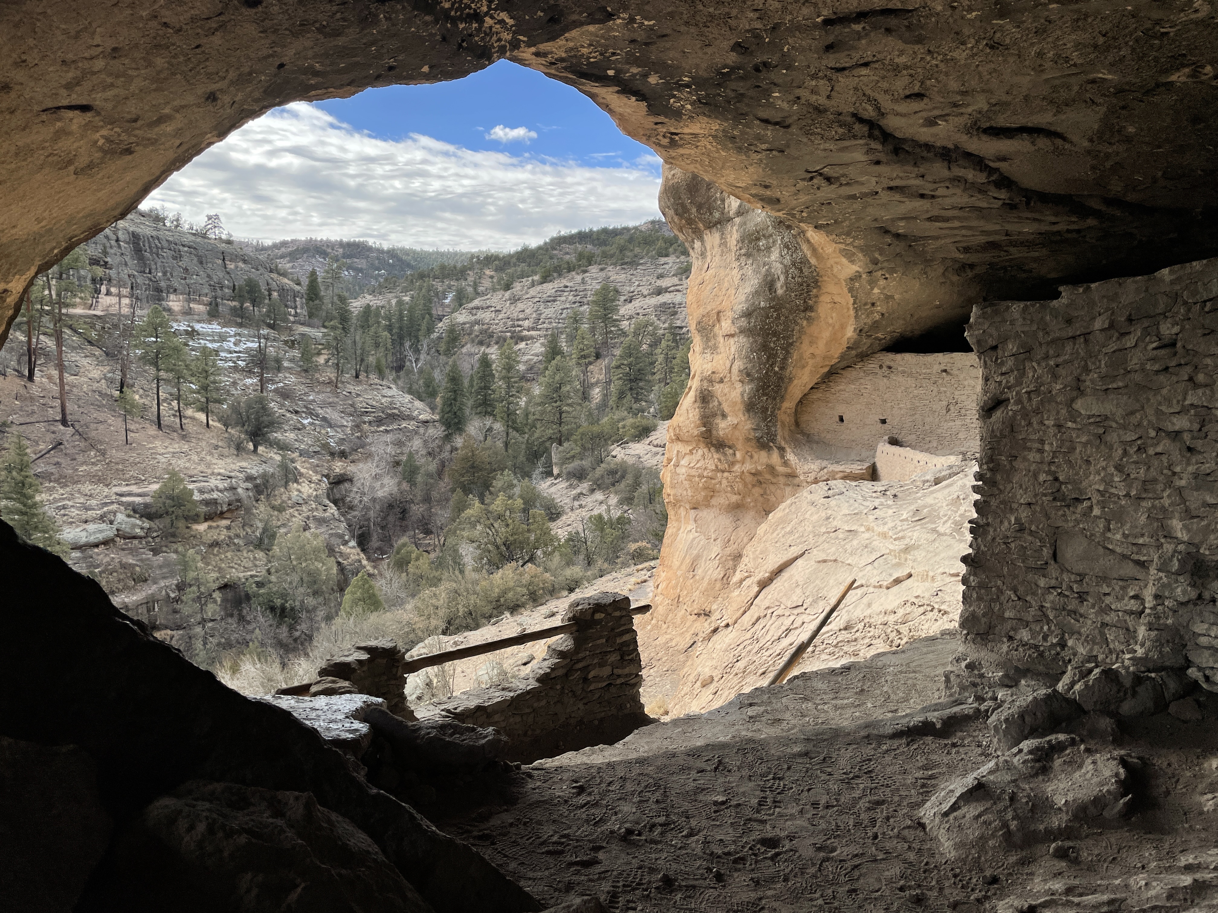
The cliff dwellings themselves were built rapidly. Tree-ring dates from the original wooden beams — still in place in the caves — show construction spanning from the 1260s through the 1280s. Archaeologists believe 10 to 15 families, perhaps 40 to 60 individuals, occupied the five alcoves, which contain 46 identified rooms. The rooms were built from local stone and mud mortar, fitted into the natural contours of each cave. Wooden beams supported roofs and floors between levels. The workmanship is deliberate and skilled, built to last — and it has.
Why the Caves? Why Here?
The choice of cliff alcoves for permanent dwellings — rather than mesa tops or river bottomlands — was not unique to the Mogollon of the Gila. Across the Southwest in the late thirteenth century, many cultures made similar moves toward elevated, defensible positions. Whether the cause was regional conflict, climate pressure, social change, or some combination of all three, the pattern was widespread. At Gila, the natural alcoves offered deep shade, shelter from weather, and sightlines over the canyon below — practical advantages that made them attractive both for temporary use over centuries and ultimately for permanent construction.
By approximately 1300, the Mogollon had moved on. There is no evidence of catastrophic abandonment — no signs of violence or sudden departure. The rooms were left intact. The community simply dissolved and dispersed, likely joining other populations elsewhere in the region. Where they went, and who their descendants are today, remains an active area of research connecting modern Pueblo peoples and other communities to the culture that built these walls.
The Apache Connection
The story of people in this landscape did not end with the Mogollon. The Gila Wilderness was — and remains — part of the traditional homeland of the Eastern Bands of Chiricahua Apache, whose oral traditions, history, and cultural identity are intertwined with these canyons and mountains. The visitor center at the monument includes exhibits on the Chiricahua Apache alongside the Mogollon archaeology, a deliberate acknowledgment that this is not a place with a single cultural story but many layers of human presence across time.
The TJ Ruin: The Other Site
The cliff dwellings get nearly all the attention, but the monument also protects the TJ Ruin — a small pueblo on TJ Mesa overlooking the Gila River, inhabited from roughly A.D. 900 to 1150, predating the cliff dwellings by more than a century. The TJ site is near the visitor center and largely unexcavated. It represents a different phase of Mogollon-related occupation in the same landscape, adding depth to the human timeline of this canyon system.
▶ Visiting the Cliff Dwellings
Start at the Visitor Center
The joint NPS/Forest Service visitor center sits near the base of the canyon, approximately a mile below the cliff dwelling trailhead. Stop here first. The museum displays Mogollon artifacts excavated from the cliff dwellings and surrounding areas — pottery, tools, and personal objects that bring the archaeological record down to a human scale. A 15-minute introductory film provides context for what you’re about to walk through. Rangers can advise on current trail conditions and seasonal access. Pick up the self-guiding trail pamphlet before heading to the trailhead.
The Cliff Dwelling Trail
The self-guided Cliff Dwelling Trail is a one-mile loop that climbs 175 feet from the canyon floor up to the cave level. The trail is rated moderate — the elevation gain is manageable, but the route includes wooden ladders, uneven stone steps, and passages that require ducking or careful footing. Allow approximately one hour for the loop at a comfortable pace, more if you plan to read the interpretive signs carefully (which you should).
The trail brings you directly into the five cave alcoves in sequence. Inside each one, original stone walls and wooden beams are within arm’s reach — this is not a roped-off, view-from-a-distance experience. You walk through the rooms. You look out the doorways. You stand where families once stood, in a canyon that has changed very little in 700 years. That intimacy is rare in the national park system and it is the defining quality of a visit to Gila.
Trail to the Past (Accessible)
For visitors unable to manage the ladders and steep sections of the main trail, the Trail to the Past offers a quarter-mile accessible route from the Lower Scorpion Campground to a small Mogollon alcove dwelling and a large pictograph panel. This trail is paved and flat, providing genuine archaeological access without the physical demands of the cliff dwelling loop.
▶ Know Before You Go
The Drive In
New Mexico Highway 15 north from Silver City is the primary route to the monument, and it earns its reputation. The 44-mile drive takes approximately 1.5 to 2 hours — it is paved throughout but features steep grades, sharp curves, and stretches where the road narrows considerably. Large vehicles and trailers face real challenges; RVs and vehicles over 20 feet should check current NPS guidance before attempting this road. Plan for the drive to be part of your day, not a quick approach. The scenery — climbing through the Gila National Forest from high desert into pine and fir mountain forest — is genuinely worthwhile.
Seasons and Weather
Spring and fall are the most comfortable seasons — moderate temperatures, manageable crowds, and good trail conditions. Summer days can be warm even at elevation, and the monument sits squarely in New Mexico’s monsoon belt: expect powerful afternoon thunderstorms from July through September, with lightning that can develop quickly over the canyon walls. Winter brings cold nights and occasional snow, but the monument typically remains accessible year-round. Always check current conditions before you leave Silver City.
Cell Service and Logistics
Cell service is extremely limited to nonexistent in the monument and along most of NM-15. Download offline maps before you leave Silver City. Fuel is available in Silver City — do not assume you can top off closer to the park. The monument has no food service; bring water and any food you need for the day. Campgrounds along the creek (Lower Scorpion and Upper Scorpion, managed by the Forest Service) offer sites for those wanting to stay overnight, making a two-day trip genuinely practical and worth considering.
Pets and Trail Access
Pets are not permitted on the Cliff Dwelling Trail. They are allowed in the surrounding Gila National Forest and at campgrounds on leash. If you’re traveling with a dog, plan accordingly — someone will need to stay back at the trailhead or campground during the cave loop.
Suggested Visit Plan
Allow a full day. The drive from Silver City takes most of the morning. Plan for 30 minutes at the visitor center, 1–1.5 hours on the Cliff Dwelling Trail, and time to decompress and take in the canyon before the return drive. Staying overnight at one of the Forest Service campgrounds turns this into a more relaxed two-day experience — the canyon in the evening, after the day-trippers have left, is something else entirely.
Why This Place Matters
The Gila Cliff Dwellings are one of the most accessible and intact examples of Mogollon architecture in the United States — and yet they remain one of the least-visited sites in the entire national park system. That combination is increasingly unusual. The rooms you walk through have not been reconstructed or heavily restored. The original wooden beams placed by Mogollon builders in the 1270s are still in the walls. The views from inside the alcoves look out over a canyon that has changed very little in seven centuries.
The monument also sits inside the Gila Wilderness — the first area in the United States to receive formal federal wilderness designation, in 1924. The landscape surrounding the cliff dwellings is protected from roads, permanent structures, and most forms of development not just by monument status but by the wilderness designation itself. What you see when you hike into that canyon is as close to the original landscape as anywhere in the Southwest. That is not an accident. It is the result of almost a century of intentional protection — and it is worth the drive.
▶ Park Map

▶ First Encounters
Watch Ranger PamPaw’s First Encounters episode for Gila Cliff Dwellings National Monument — first impressions of the canyon, the approach trail, and what it feels like to walk through 700-year-old rooms still standing in the cliff above the Gila River.
▶ Further Exploration
- Gila Cliff Dwellings National Monument — NPS Official Site
- Plan Your Visit — Hours, Fees & Conditions
- History & Culture — The Mogollon and the Cliff Dwellings
- NPS Overview Article — Gila Cliff Dwellings
- Gila National Forest — U.S. Forest Service
- The Gila Wilderness — America’s First Wilderness Area
- Visit Silver City — Lodging, Dining & Services

Listen to the Ranger PamPaw Podcast
Stories, perspective, and park wisdom from a lifetime in the National Parks. Available wherever you listen to podcasts.