Category: Travel Blog

Tezels on the Road is our family’s travel journal—capturing the adventures, mishaps, and magic of life on the move. From scenic drives and national parks to hidden gems and roadside surprises, we share stories, tips, and snapshots from the journey.

  • Ranger PamPaw’s Guide

    Chiricahua National Monument

    Arizona’s Wonderland of Rocks

    Willcox, Arizona  ·  Dos Cabezas Mountains  ·  Est. 1924

    ▶ A Note from Ranger PamPaw

    “Chiricahua stops people in their tracks. There’s nowhere else in the park system quite like it.”

    Welcome to Arizona’s Wonderland of Rocks — a sky-island landscape of volcanic pinnacles, balanced rocks, and deep natural and cultural history. This guide supplements our First Encounters episode on Chiricahua, offering everything you need to plan your own visit.

    Few national monument units reward a slow visit more than this one. The drive in, the hike through the formations, the quiet of the campground at night — Chiricahua is the kind of place that earns a return trip before you’ve even left.

    — Ranger PamPaw

    ▶ Quick Facts

    DesignationNational Monument
    EstablishedApril 18, 1924 — to protect the volcanic rock formations and cultural history of the Dos Cabezas Mountains
    Location12856 E Rhyolite Creek Rd, Willcox, AZ 85643 — southeastern Arizona, ~120 miles east of Tucson
    Size11,985 acres within the Coronado National Forest
    Why It’s FamousThousands of rhyolite rock pinnacles, balanced rocks, and spires known as the “Wonderland of Rocks”
    AdmissionFree — no entrance or parking fees
    Visitor Center HoursOpen daily 8:30 a.m. – 4:30 p.m.; closed Christmas Day — check nps.gov/chir for seasonal updates
    Trails17+ miles of maintained trails; Echo Canyon Loop (3.3 mi), Heart of Rocks Loop (7 mi), Massai Point Nature Trail (0.5 mi)
    CampgroundBonita Canyon — 23 sites, reservation-only via recreation.gov; vehicle length limit typically 29 feet
    PetsLeashed pets permitted in parking areas and on the Bonita Canyon Drive; not permitted on trails
    NPS Websitenps.gov/chir

    ▶ How the Wonderland of Rocks Was Made

    The Turkey Creek Caldera

    Approximately 27 million years ago, a massive volcanic eruption — centered on what geologists now call the Turkey Creek Caldera — blanketed this region of southeastern Arizona in a thick layer of ash and volcanic debris. That material compressed and hardened over millions of years into rhyolite tuff, a relatively soft volcanic rock. Then erosion went to work: water, frost, and wind slowly carved the tuff into the improbable landscape visible today — columns, spires, balanced rocks, and pinnacles that seem to defy gravity at every turn.

    The formations are concentrated in the upper reaches of Bonita Canyon, where the geology produced the densest and most dramatic clustering of pinnacles in the monument. This is the heart of what visitors and writers have long called the Wonderland of Rocks — a name that understates the place just enough to let the reality of it land as a genuine surprise.

    The Sky Islands

    Chiricahua sits within one of the most ecologically rich corners of North America — the Sky Islands of southeastern Arizona and northern Mexico. These isolated mountain ranges rise dramatically from the surrounding desert, each one functioning as an ecological island. The elevation gradient within the Chiricahua Mountains alone spans desert scrub at the base to pine, fir, and Douglas-fir forest at the upper elevations, supporting a remarkable diversity of plant and animal life compressed into a relatively small area. Rare birds, including elegant trogons and sulfur-bellied flycatchers, draw birders from across the country.

    The Faraway Ranch and the Erickson-Riggs Legacy

    The monument’s human story is anchored in the Faraway Ranch, homesteaded by Swedish immigrant Neil Erickson in the 1880s. His daughter Lillian, who married Ed Riggs, spent decades advocating for protection of the rock formations she had grown up exploring. The Riggs family developed early tourist facilities in the canyon and lobbied persistently for national monument designation — which came in 1924. Faraway Ranch is listed on the National Register of Historic Places and remains within the monument boundary. The historic district is currently under renovation, but the grounds are accessible and worth a walk.

    The Chiricahua Apache Connection

    These mountains were the stronghold and homeland of the Chiricahua Apache — the same people at the center of the conflict at nearby Fort Bowie. The Chiricahua Mountains gave Cochise’s band both refuge and identity. The landscape that visitors walk through today for its geology was, not long ago, the terrain that shaped one of the most consequential chapters in the story of the American Southwest. That history is present here, woven into the place itself.

    ▶ Touring the Monument

    The Bonita Canyon Drive

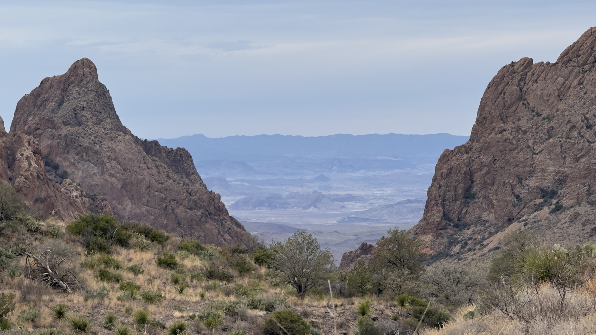
    The 8-mile Bonita Canyon Drive is the monument’s primary corridor, climbing from the visitor center at the entrance through oak, pine, and cypress forest to Massai Point at the upper end. The drive takes about 20 minutes at speed but rewards a slower pace — pull-outs offer increasingly dramatic views of the formations as the road ascends. At Massai Point, an overlook delivers 360-degree views of the Wonderland of Rocks and the surrounding mountains, including the Dragoon Mountains to the northwest where Cochise’s Stronghold is located. This is a strong orientation stop before committing to a hike.

    Hiking Options

    Echo Canyon Loop (3.3 miles, moderate) — The essential first-visit hike. The loop descends into Echo Canyon through narrow corridors and shaded grottoes, passes through the Grottoes formation, and transitions to the Hailstone Trail before climbing back via the Ed Riggs Trail. The variety of terrain — tight passages, open overlooks, changing vegetation — makes this the most complete single hike in the monument. See our dedicated Echo Canyon Loop Trail Guide for the full breakdown.

    Massai Point Nature Trail (0.5 miles, easy) — A short loop from the upper parking area at Massai Point through the formations with interpretive signage. Strong option if time or energy is limited; the views justify the drive regardless.

    Heart of Rocks Loop (7 miles, strenuous) — The longer, more demanding route through the monument’s most remote formations, including named features like Punch and Judy, Big Balanced Rock, and Camel Head. Best suited to a second visit or for experienced hikers with a full day. The payoff is solitude and access to formations that most visitors never reach.

    Echo Canyon Grottoes (1 mile, easy-moderate) — A shorter out-and-back that captures the signature grottoes and slot-canyon passages of Echo Canyon without the full loop commitment. A practical choice for families or those short on time.

    ▶ Know Before You Go

    Getting There

    Chiricahua is located about 120 miles east of Tucson via I-10 and AZ-186. The approach road is paved to the visitor center. Large vehicles should note that the Bonita Canyon Drive has some tight curves; the campground has a 29-foot vehicle length limit. The monument is about 25 miles from Fort Bowie National Historic Site — the two parks make a natural two-day combination along this stretch of southeastern Arizona.

    Seasons and Fire Restrictions

    Spring and fall are the most comfortable seasons for hiking — mild temperatures and lower crowds. Summer brings warm days and afternoon monsoon thunderstorms from July through September. Chiricahua frequently experiences spring fire restrictions limiting campfires and stoves at campsites; check current fire conditions at nps.gov/chir before your visit. Winter is generally mild at lower elevations but can bring occasional snow and ice on the upper trails and drive.

    Camping at Bonita Canyon

    The Bonita Canyon Campground offers 23 shaded sites with flush toilets and potable water. Reservations are required through recreation.gov. There are no hookups or dump station. The 29-foot vehicle length limit is enforced — verify your vehicle dimensions before booking. Staying overnight is strongly recommended; the canyon in the early morning, before day visitors arrive, is a different experience entirely from a day trip.

    Pets and Trail Access

    Pets are not permitted on monument trails. Leashed pets are allowed in the parking areas, picnic areas, and campground. Plan accordingly if you’re traveling with a dog — the surrounding Coronado National Forest has trails where pets are permitted on leash.

    Why This Place Matters

    Chiricahua protects one of the most visually distinctive landscapes in the entire National Park System — and one of the least visited. The volcanic geology that created these formations is found nowhere else in the country in this concentration or scale. But the geology is only one layer. The Sky Island ecology, the Chiricahua Apache cultural history, and the ranching heritage of the Faraway Ranch give this place a depth that most visitors only begin to appreciate on a second or third visit.

    The combination of free admission, a scenic drive that works for any ability level, and one of the best moderate hikes in Arizona makes Chiricahua an extraordinary value as a travel destination. Give it a full day — and if you can stay the night, do it. This is a place that rewards the people willing to slow down and let it work on them.

    ▶ Park Map

    Official NPS map of Chiricahua National Monument showing Bonita Canyon Drive, Massai Point, Echo Canyon trailhead, Faraway Ranch, and the Bonita Canyon Campground

    ▶ First Encounters

    Watch Ranger PamPaw’s First Encounters episode for Chiricahua National Monument — first impressions of the Wonderland of Rocks, the Bonita Canyon Drive, and what it’s like to hike into a landscape unlike anything else in the National Park System.

    ▶ Further Exploration

    The Ranger PamPaw Podcast — Tezels on the Road

    Listen to the Ranger PamPaw Podcast

    Stories, perspective, and park wisdom from a lifetime in the National Parks. Available wherever you listen to podcasts.

  • Trail Guide – Boquillas Canyon

    Boquillas Canyon Trail

    Big Bend National Park / Río Grande Wild and Scenic River• Texas

    The Boquillas Canyon Trail is a short, rewarding hike into Big Bend National Park’s largest canyon. This easy walk follows the Rio Grande to the mouth of Boquillas Canyon, where towering limestone walls and the quiet flow of the river create one of Big Bend’s most memorable scenes.

    • Distance: ~1.5 miles round trip
    • Elevation: ~150 feet (short initial climb)
    • Difficulty: Easy
    • Type: Out & Back
    • Time: ~1 hour

    East trail to just inside the canyon mouth.

    From Rio Grande Village, drive the signed spur road to Boquillas Canyon. The trailhead lies at the end of the road. 

    • Overlook early in the hike with sweeping views of the Rio Grande and the canyon mouth.
    • Sand hill on the left (within the canyon) that has shifted over time due to slides and wind.
    • Towering limestone walls and the tranquil soundscape of the river.

    Boquillas Canyon offers a high reward for a short distance: big scenery, river sounds, and a powerful sense of place. It’s an easy way to experience one of Big Bend’s signature canyons without a long or strenuous hike.

    • Footwear: Sturdy shoes with good traction for the initial climb and sandy sections.
    • Timing: Mornings and late afternoons offer softer light and cooler temperatures.
    • Water & Sun: Carry water and sun protection—shade is limited once you leave the canyon walls.

    We featured this hike in a special edition of Tuesdays on the Trail, highlighting both the experience and why access to places like Boquillas Canyon matters.

    Short reflective closing encouraging readers to experience the trail themselves

  • Trail Guide – Cliff Dwelling Trail

    Cliff Dwellings Trail

    Gila Cliff Dwellings National Monument • New Mexico

    The Cliff Dwellings Trail at Gila Cliff Dwellings National Monument may be short, but it is one of the most memorable walks in the National Park System. This easy-to-moderate loop trail is the only way to see the monument, leading visitors through a shaded canyon and into ancient cliff dwellings built more than 700 years ago.

    • Distance: ~1 mile
    • Elevation Gain: ~180 feet
    • Difficulty: Easy to Moderate (ladders required)
    • Trail Type: Loop
    • Typical Hiking Time: ~1 hour

    This trail is the only way to access the park. While there are steps and ladders to access the cliff dwellings, most people, including families, should be able to hike at least part of the trail.

    Reaching Gila Cliff Dwellings National Monument is part of the experience. From Silver City, a winding mountain road leads deep into the Gila Wilderness, the first designated wilderness area in the United States. By the time you arrive at the trailhead at the end of Cliff Dwellings Road, the landscape already feels remote and quiet.

    In the late 1200s, people of the Mogollon culture built these dwellings and lived here for one or two generations. They constructed rooms from stone and mortar, raised families, and relied on the natural shelter provided by the caves.

    A series of ladders allows visitors to climb into the dwellings themselves. Walking through these rooms is the highlight of the hike, offering views across the canyon and a powerful sense of connection to the people who once lived here.

    The Cliff Dwellings Trail is more than a short walk. It combines natural beauty, cultural history, and a strong sense of place, all within the setting of the Gila Wilderness. Though brief, the experience leaves a lasting impression.

    • Wear sturdy shoes with good traction.
    • Take your time exploring the dwellings.
    • Visit earlier in the day for cooler temperatures and fewer crowds.
    • Follow posted rules to help protect these fragile structures.

    This trail guide pairs with our Tuesdays on the Trail video episode, where we walk the Cliff Dwellings Trail and explore the dwellings themselves.

    The Cliff Dwellings Trail may only be about a mile long, but it delivers one of the most meaningful trail experiences in southwestern New Mexico. For visitors willing to make the drive, it offers a rare chance to walk through history in a quiet, beautiful setting.

  • Big Bend Road Trip 2026: Scrambling Grapevine Hills and Soaking in Juniper Flats Views

    Big Bend Road Trip 2026: Scrambling Grapevine Hills and Soaking in Juniper Flats Views

    Day 3 – Grapevine Hills and Juniper Flats

    We eased into the day with a slow morning, lingering over coffee and soaking in the views of the Chisos Mountains right outside our window. Nature provided an unexpected show as clouds appeared to pour over the mountain rim and spill into the Basin below—a mesmerizing sight that reminded us why Big Bend National Park is so special.

    By late morning, we were ready to head out for our first hike: Grapevine Hills. Reaching the trailhead is an adventure of its own, with a gravel road that can be rough in spots but is well worth the effort.

    The Grapevine Hills are a fascinating laccolith, formed when magma pushed upward beneath the surface and later erosion exposed the rock. Up close, the hills look like a chaotic jumble of massive boulders. The hike begins easily, following a dry wash through the center of the formation. That changes in the final quarter mile, where the trail climbs into the rocks and turns into a true scramble.

    We took our time navigating the boulders, carefully picking our way upward. While keeping our balance, we couldn’t help but think how much our grandkids would love this kind of hands-on adventure. The payoff comes at the end: a massive boulder perfectly balanced atop two others, framing a stunning view of the distant Chisos Mountains—one of Big Bend’s most iconic sights.

    After lunch back in the Basin, we set out for the final hike of this trip: the Pinnacles Trail to Juniper Flats. Like many Chisos trails, the views are rewarding all along the way, but the climb to Juniper Flats—about 240 feet above the Basin—opens up an especially impressive panorama. From this vantage point, we could take in Casa Grande to the east, Toll Mountain and Emory Peak to the south, the Window to the west, and the Basin spread out below us to the north.

    The Pinnacles Trail continues deeper into the high Chisos, eventually reaching Boot Canyon and the South Rim. That kind of strenuous trek wasn’t in the cards for this trip, but it definitely got us wondering whether it might be possible in the future—with a more dedicated training program. Big Bend has a way of inspiring new goals.

    We wrapped up our day with a short ranger-led walk near the Window View Trail, learning more about the park’s natural and human history. Just as we returned to our room, the Chisos Mountains ignited with deep reds and oranges as the sun set. It was the perfect ending to a memorable final evening in Big Bend National Park.

    See our Short from today’s adventures…

  • Day 2: Lost Mine Trail & Boquillas Canyon

    Day 2: Lost Mine Trail & Boquillas Canyon

    We woke to damp ground and low clouds drifting through the Chisos Basin, the result of light rain overnight. It wasn’t the most promising start for a hike on one of our favorite trails—Lost Mine—but in Big Bend, patience is often rewarded.

    The drive up to the trailhead at Panther Pass did little to boost our confidence. The sky stayed gray, and expectations were modest. Still, we found a parking spot—no small victory these days—and decided to take our chances. It turned out to be the right call.

    The Lost Mine Trail begins with a steady, moderate climb, and almost immediately delivers. The first three-quarters of a mile wind upward through welcome shade, offering expanding views into Green Gulch and the Basin Road climbing into the Chisos. The oak, juniper, and pine woodland here feels worlds away from the dry scrub of the Chihuahuan Desert below, a reminder of how dramatically Big Bend’s landscapes can shift with elevation.

    At the three-quarter-mile mark, the trail tops out on a ridge above Juniper Canyon, where the views begin to open and the work really starts. A seemingly endless series of switchbacks carries you higher, each turn revealing a little more of the park. At the top, the reward is one of the finest panoramas in Big Bend: Juniper and Pine Canyons and the southern Chisos to the south, the vast Chihuahuan Desert stretching east, Casa Grande rising to the west, and Lost Mine Peak to the north—its name tied to legends of Spanish prospectors searching for riches in these mountains.

    Just as we reached the summit, the clouds parted. The views were clear, dramatic, and fleeting. On the descent, the clouds rolled back in, and by the time we reached the parking lot, light rain had returned. Once again, our timing felt just about perfect.

    After lunch, we headed east toward Boquillas Canyon, one of the three major canyons carved by the Rio Grande. Rain followed us most of the way, falling harder as we drove, but as luck would have it, it stopped just as we arrived at the trailhead.

    The half-mile trail into the canyon is short and mostly easy, with a brief climb at the start. Inside the canyon, steep limestone walls close in, creating a quiet, intimate space that contrasts sharply with the openness of the desert. Twenty years ago, we brought two of our boys here, where they spent endless time climbing and sliding down a large sand hill. Today, that hill has been narrowed by a rockslide—time leaving its mark, as it always does.

    As we headed back toward the car, the rain returned, heavier this time. Fortunately, the trail is short, and we made it back without getting completely soaked.

    Back in the Chisos Basin, the day wound down quietly. Dinner on our balcony came with a front-row seat to sunset colors washing over Emory Peak, the clouds finally beginning to thin. But the day wasn’t quite finished.

    AThat evening, we drove down to Panther Junction for a ranger-led Star Talk. As an International Dark Sky Park, Big Bend delivers night skies that still feel overwhelming. Telescopes were set up, celestial objects came into focus, and stars filled every dark space above us.

    Tomorrow, we look forward to more hiking. If today was any indication, Big Bend still has plenty to offer.

    Watch our YouTube Short of the day:

  • Day 1 – Arriving in the Chisos Basin

    Day 1 – Arriving in the Chisos Basin

    Though long, the drive across West Texas is always worth it. Around 4:15 p.m., we turned onto the Basin Road and began our ascent into the Chisos Mountains. The higher we climbed, the desert shrubs gradually gave way to trees, transforming the landscape outside our windows.

    Soon, we were navigating the familiar switchbacks up to Panther Pass, cresting the divide and crossing into the Basin. This stretch is always memorable as the road descends into the high mountain valley, with the Window framed perfectly at the far end. No matter how many times we make this drive, it never fails to impress.

    After checking into our hotel room—home base for the next three nights—and unpacking, we set out for an easy walk on the Window View Trail. The flat, paved path offers little challenge, but the payoff is enormous. The views down through the Window and out across the desert below are simply breathtaking.

    We capped off the day with a simple dinner on our balcony, soaking in views of Emory Peak and the surrounding Chisos Mountains. Clouds obscured the sunset, but the wispy layers caught the fading light and created a quiet show of their own.

    It’s good to be back in Big Bend.

    Watch today’s YouTube Short…

  • The Long Road to Big Bend

    The Long Road to Big Bend

    West Texas stretches out in front of us, mile after mile of open road and widening sky. The drive has a rhythm now—long straightaways, the occasional small town, the sense that we’re leaving one world and easing into another. Cell service fades, radio stations come and go, and the landscape simplifies until it’s mostly earth, sky, and time.

    With every mile, Big Bend feels closer, even before we can see it. Mesquite and creosote line the highway, distant ridges ripple along the horizon, and the quiet grows more noticeable. This is the kind of drive that demands patience, but rewards it too. The remoteness is the point.

    Soon, the Chisos Mountains will rise ahead of us, and the road will begin to climb. By late afternoon, we expect to wind our way up into the Chisos Basin, just just in time to watch the sunset through the Window. After a full day on the road, the thought of pulling in, stepping out into cooler air, and finally being there is enough to keep us rolling.

    Big Bend is one of our favorite parks, and even before we arrive, it’s already doing what it does best—slowing us down and pulling us in.

    🎥 A look back at our very first Big Bend visit:

  • Southern Caribbean Cruise 2026 – Day 10

    Southern Caribbean Cruise 2026 – Day 10

    San Juan, Puerto Rico: History, Mofongo, and a Relaxed Farewell

    Our Southern Caribbean Cruise 2026 officially came to an end this morning as we woke up once again in San Juan, Puerto Rico. While the cruise itself was over, our Caribbean adventure wasn’t quite finished yet.

    After saying goodbye to the wonderful crew aboard the Grand Princess, we disembarked and headed to the airport to pick up a rental car. From there, we drove to the Courtyard by Marriott Isla Verde Beach Resort, where we dropped off our luggage and prepared to spend our final night in paradise.


    Exploring Old San Juan

    With the logistics out of the way, we made our way into Old San Juan, one of the most atmospheric and historic cities in the Caribbean. After parking, we spent the morning wandering the narrow, colorful streets of the old city, popping into shops and soaking in the sights and sounds of this vibrant port.

    Hunger eventually led us to Los Yeyo’s, a restaurant proudly known as “The House of Mofongo.” That alone made it an easy decision.

    We shared a crab mofongo along with a side of sweet plantains, and it did not disappoint. The mofongo arrived on a sizzling skillet, filling the air with an irresistible aroma. For those unfamiliar, mofongo is a traditional Puerto Rican dish made from fried plantains mashed with garlic and other ingredients. Los Yeyo’s crab mofongo was absolutely outstanding and easily one of our favorite meals of the trip.

    Castillo San Felipe del Morro (El Morro)

    After lunch, we continued exploring Old San Juan until we reached Castillo San Felipe del Morro, part of San Juan National Historic Site. Perched high on a promontory overlooking the entrance to San Juan Bay, El Morro is one of the most impressive fortifications in the Caribbean.

    Constructed over more than 250 years by Spanish engineers, El Morro reflects Spain’s determination to protect San Juan as a critical hub in the trans‑Atlantic trade routes. Walking along its massive walls and gazing out from its strategic vantage point, it’s easy to understand why such effort and resources were invested here. The fortress feels immense—an imposing, nearly impenetrable stronghold guarding the city.

    San Juan’s Defensive Network & Castillo San Cristóbal

    El Morro was only one element of San Juan’s elaborate defensive system. San Juan National Historic Site also preserves large sections of the original city walls, which completely encircled the city by 1783, as well as Fort San Juan de la Cruz (El Cañuelo) on the opposite side of the harbor.

    Our next stop was Castillo San Cristóbal, the largest fortification built by Spain in the New World. Unlike El Morro, San Cristóbal was designed primarily to defend the city from land-based attacks. Its sheer scale and layered defenses are just as impressive, showcasing remarkable military engineering and ingenuity.

    Together, these fortifications tell stories of ambition, empire, and conflict. For centuries, nations fought for control of this small but strategically vital island. Generations of soldiers lived and worked within these walls, and today visitors are inspired not only by the history, but also by the beauty and brilliance of this UNESCO World Heritage Site.

    A Relaxed Caribbean Evening

    After spending the afternoon immersed in over 500 years of history, we returned to the Courtyard by Marriott Isla Verde Beach Resort. Our room wasn’t quite ready, but that was hardly a problem. We found seats by the beach, ordered some sangria, and simply relaxed—reflecting on an unforgettable week in the Caribbean.

    Tomorrow brings a calm, easy morning before our late‑afternoon flight home to San Antonio. There’s no sign of winter weather here in San Juan, so we’re hoping that the weather on the mainland doesn’t affect our trip home.

  • Southern Caribbean Cruise 2026 – Day 9: A Perfect Sea Day on the Grand Princess

    Southern Caribbean Cruise 2026 – Day 9: A Perfect Sea Day on the Grand Princess

    Day 9 of our Southern Caribbean Cruise was our only full sea day, and we were more than ready for it. While we loved every port of call on this cruise, there’s something especially wonderful about a relaxed day at sea—no alarms, no shore excursions to rush to, and no embarkation or disembarkation schedules to manage.

    Sea days on Princess Cruises always seem to arrive at just the right moment, and this one was no exception.


    Culinary Demonstration: A Princess Cruises Favorite

    As is tradition on the last sea day of a Princess cruise, we attended one of our favorite onboard events: the Culinary Demonstration in the Princess Theater.

    The ship’s Executive Chef Arturo and Director of Restaurant Operations, Erdal, gave us a fascinating behind‑the‑scenes look at what it takes to feed nearly 2,700 passengers every day. Chef Arturo then took center stage, preparing a beautiful Pasta al Pesto and spicy Diablo Shrimp, with Erdal assisting. As always, the aromas alone were worth the visit, filling the entire theater.


    Black Forest Cake (and a Little Friendly Competition)

    After the savory dishes were complete, the attention turned to dessert. The head pastry chef created an absolutely stunning Black Forest Cake, showcasing the high level of skill found in Princess Cruises’ pastry kitchens.

    As usual, Erdal joined in with his own version of the cake. While perhaps not as visually refined as the pastry chef’s creation, it added a dose of humor to the demonstration—a reminder that these events are as entertaining as they are informative.


    A Behind‑the‑Scenes Galley Tour

    Following the demonstration, we were treated to a guided tour of one of the two main galleys aboard the Grand Princess. Walking through the kitchen really drives home the scale of the operation and the level of organization required to keep thousands of passengers happily fed.

    Seeing where all that food is prepared made lunch later at the Horizon Court even more enjoyable—especially knowing we were tasting some of the very dishes we had just watched being prepared.


    Our Final Evening at Sea

    A lazy afternoon onboard led us into our final evening at sea. We enjoyed one last dinner in the elegant Michelangelo Dining Room, followed by the Farewell Variety Show in the Princess Theater.

    Entertainers Ashley Rose Smith and Radio Recall, who had performed earlier in the cruise, returned for one final performance. The show concluded with a moving moment as crew representatives filled the stage, giving passengers the chance to thank the entire crew with a heartfelt standing ovation.


    Looking Ahead to San Juan

    Tomorrow morning, we arrive back in San Juan, Puerto Rico. While it will be time to disembark the Grand Princess, our journey isn’t quite over yet—we’ll still have a full day in Puerto Rico before flying home Monday evening.

    Sea days like this one are the perfect way to reflect, relax, and savor the final moments of an unforgettable Southern Caribbean cruise.

Verified by MonsterInsights