Tag: Southern Caribbean Cruise 2026

Our first trip of 2026 is a cruise from San Juan, Puerto Rico to the Virgin Islands, Sint Maarten, Antigua, Dominica, and Barbados

  • Science and Conservation Trail

    Where the Only Tropical Rainforest in the U.S. Meets the Work of Puerto Rican Artists

    The Science and Conservation Trail at El Yunque National Forest is a short loop — about half a mile — that manages to deliver two entirely different kinds of experiences. A paved spur from the El Portal del El Yunque visitor center leads into the forest with interpretive signs explaining the ecology and ongoing recovery of the only tropical rainforest in the United States National Forest System. The loop itself adds a second dimension: works by Puerto Rican artists set directly into the forest — Brota el agua by Lena Galíndez, De Río a Río by Edra Soto, and La Madre de Yocahú by Daniel Lind-Ramos. It is a walk where science and art share the same canopy, and both are made richer for it.

    Trail Facts

    • Distance: ~0.5 miles (loop)
    • Elevation Gain: Minimal — gentle grade throughout
    • Difficulty: Easy
    • Trail Type: Loop (paved path)
    • Typical Hiking Time: 20–30 minutes
    • Trailhead: El Portal del El Yunque Visitor Center, off PR-191, Río Grande, Puerto Rico
    • Accessibility: Paved surface throughout; accessible for most visitors
    • Pets: Allowed on leash
    • Entry Fee: Day-use vehicle fee required for entry to El Yunque National Forest

    The Science and Conservation Trail is one of several walking paths accessible from the El Portal visitor center area. Its combination of interpretive science content and public art installations makes it unlike any other trail in the National Forest System — and the rainforest setting makes it unlike anything else in the continental United States.

    Getting to the Trailhead

    The trail begins at El Portal del El Yunque, the main visitor center for El Yunque National Forest. El Portal is located along Puerto Rico Highway 191 (PR-191) near the northern entrance to the forest, just outside the town of Río Grande on Puerto Rico’s northeastern coast. From San Juan, the drive takes approximately 45 minutes. El Portal is the recommended first stop — the center provides maps, orientation, and context for the forest before you head into the canopy.

    El Yunque National Forest is located in the Sierra de Luquillo mountains in the northeastern corner of Puerto Rico, roughly 25 miles east of San Juan. The forest is the only tropical rainforest in the United States National Forest System, and El Portal sits at its edge — the gateway between the island’s coastal communities and one of the most biodiverse places in the country.

    Hiking the Trail

    From El Portal, a short paved spur path leads from the visitor center directly into the forest. This opening section is where the trail’s interpretive content lives — signs along the spur explain El Yunque’s ecology, the ongoing research being conducted in the forest, and the remarkable recovery underway since Hurricane Maria struck the island in September 2017. The spur is accessible, unhurried, and sets the scientific frame for everything that follows.

    The loop itself begins where the spur enters the forest proper. Here the character of the walk shifts. The canopy closes in — sierra palms, tabonuco trees, and towering tree ferns rise on either side, draped in bromeliads and mosses. The air is heavy and cool, carrying the particular quality of a place that receives over 100 inches of rain per year in its upper elevations. And woven into this setting, at intervals along the loop, are works by Puerto Rican artists — installations placed directly in the forest, responding to this place and to the island’s history and culture. Brota el agua by Lena Galíndez meets you on the north segment, deep in the canopy. De Río a Río by Edra Soto anchors the westernmost point of the loop. And La Madre de Yocahú by Daniel Lind-Ramos — a monumental assemblage invoking the Taíno goddess Atabey — marks the southern return.

    The loop is short enough to walk without hurry and rich enough to reward stopping. The combination of science interpretation on the spur and art on the loop gives the trail two distinct registers — both worth paying attention to. The return brings you back out to El Portal through the same forest edge, the transition from canopy to open sky feeling different on the way out than it did on the way in.

    Highlights Along the Way

    The Forest Itself

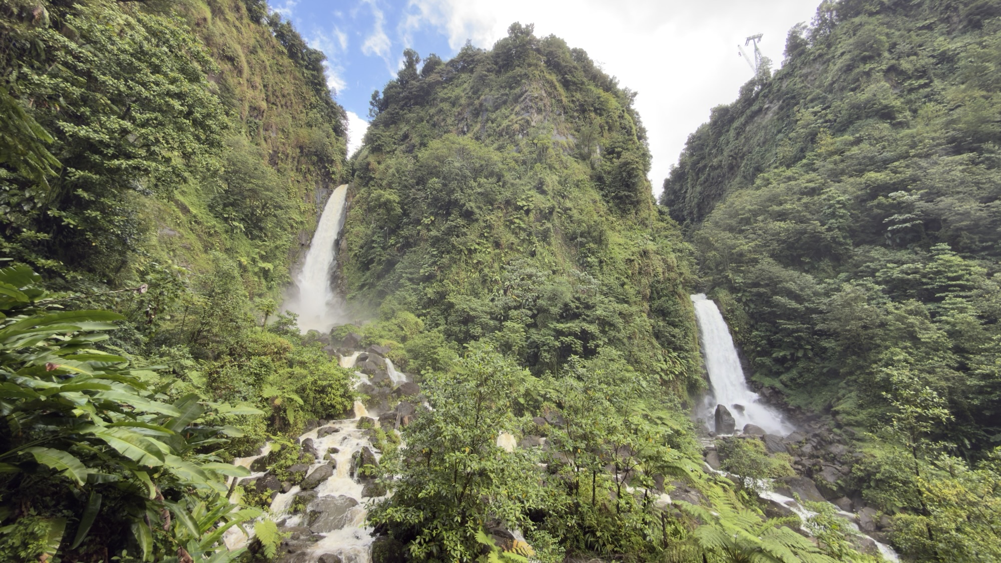
    El Yunque is the most visited national forest in the United States — and the most biodiverse. The forest is home to more than 240 tree species, 50 of which are found nowhere else on Earth. The understory along the Science and Conservation Trail is dense with tree ferns, some belonging to genera that predate the dinosaurs. Epiphytes — bromeliads, orchids, mosses — coat nearly every surface. The sounds of the forest are as layered as the canopy: coquí frogs, birds, insects, and the constant movement of water.

    Brota el agua — Lena Galíndez

    Brota el agua — Water Springs Forth — by Lena Galíndez is installed on the northern segment of the loop, where the trail is deepest in the forest. The title speaks directly to El Yunque’s defining element: water is everywhere here, rising through the roots, dripping from the canopy, moving constantly through the soil. Galíndez’s work places that relationship between water and life at the center, inviting a kind of attention to the forest that pure ecology interpretation can only gesture toward.

    De Río a Río — Edra Soto

    Edra Soto is a Chicago-based artist born in Puerto Rico whose practice engages deeply with Puerto Rican identity, domestic space, and visual culture. De Río a Río — From River to River — is installed at the westernmost point of the loop, its title resonant in a place where water is everywhere: in the canopy, in the soil, running through the roots of every tree. Soto’s work in El Yunque places Puerto Rican artistic expression directly in the landscape that shaped the island’s culture, creating a conversation between the forest and the people who have always lived within and beside it.

    La Madre de Yocahú — Daniel Lind-Ramos

    Daniel Lind-Ramos is one of Puerto Rico’s most celebrated contemporary artists, known for large-scale assemblage sculptures that draw on Afro-Caribbean spiritual traditions, the island’s agricultural history, and the natural world. La Madre de Yocahú — The Mother of Yocahú — takes its name from Atabey, the Taíno goddess of fresh water and fertility, and mother of Yocahú, the supreme deity of the Taíno people. The title is a deliberate invocation of the forest’s deep human history: El Yunque takes its name from the Taíno word Yuké, and the mountain has been a sacred place for far longer than it has been a national forest. Lind-Ramos’s work on the southern return of the loop anchors the trail’s artistic program in the spiritual and cultural landscape that predates European contact — and that the forest has always carried.

    The Recovery Story

    The interpretive signs along the spur tell a story that is still unfolding. Hurricane Maria made landfall on Puerto Rico on September 20, 2017 as a Category 4 storm and stripped the canopy from nearly the entire forest. Scientists who had studied El Yunque for decades described it as unrecognizable. But the forest’s species have survived hurricanes for millennia — the trees here evolved to come back — and the regrowth in the years since has been extraordinary. Walking the trail today, it is possible to see both the evidence of the storm and the evidence of recovery in the same glance.

    What Makes This Trail Special

    The Science and Conservation Trail asks very little of your legs and a great deal of your attention. In half a mile, it moves through science, art, ecology, and culture without any of them feeling forced together. The forest is extraordinary on its own terms — there is nothing else like a tropical rainforest in the National Forest System, and the sensory experience of the canopy, the ferns, the heavy air, and the sound of coquís is genuinely unlike any other trail in this series. The three art installations add a layer that most trails never attempt: the idea that this landscape is also a cultural space, shaped by and belonging to the people of Puerto Rico. Galíndez listens to the water. Soto traces the rivers. Lind-Ramos reaches back to the Taíno. Together they make the loop something more than a walk — they make it a conversation with the island itself.

    Tips for Visiting

    • Start at El Portal — the visitor center provides maps, restrooms, and orientation to the forest before you head out.
    • Come prepared for rain. El Yunque receives over 100 inches annually in its upper elevations — a light rain layer or poncho is worth carrying year-round.
    • Bring bug spray. The forest is prime mosquito territory, especially after rain.
    • Walk the spur slowly before the loop — the interpretive signs establish context that makes the art installations more meaningful.
    • Give each art installation time — Brota el agua, De Río a Río, and La Madre de Yocahú each reward a slow look. They are not roadside stops; they are part of the forest.

    El Yunque and the National Forest System

    El Yunque National Forest has been under federal protection longer than the National Forest System itself. The forest was first set aside by President Theodore Roosevelt in 1903 as the Luquillo Forest Reserve — one of the earliest federal forest reserves in the United States — and was formally incorporated into the National Forest System in 1935. It is administered by the USDA Forest Service and covers approximately 28,000 acres in the Sierra de Luquillo mountains. El Yunque is the only tropical rainforest in the National Forest System, and as such it serves as one of the most important sites for tropical ecology research in the country. The Luquillo Long-Term Ecological Research site — part of a network funded by the National Science Foundation — has produced decades of data on forest structure, species diversity, disturbance, and recovery, much of which informs the interpretive content along the Science and Conservation Trail.

    The forest sits within the traditional territory of the Taíno people, whose presence in Puerto Rico predates European contact by more than a thousand years. The name Yuké — meaning white lands, likely a reference to the clouds that perpetually wrap the upper peaks — is the Taíno name for the mountain at the forest’s heart, and the source of the name El Yunque. The forest’s long history of human connection, from the Taíno through Spanish colonial administration to U.S. federal protection, is part of what makes El Portal and its trails a layered experience. The Science and Conservation Trail, with its combination of ecological research and Puerto Rican artistic expression, sits squarely in that tradition.

    Tuesdays on the Trail Video

    This trail guide pairs with our Tuesdays on the Trail video episode, where we walk the Science and Conservation Trail and explore the forest, the art, and the story of El Yunque’s recovery.

    Final Thoughts

    Half a mile is a short walk by almost any measure. But the Science and Conservation Trail at El Yunque earns its place in this series not through distance but through density — the density of the forest itself, the density of its ecology and history, and the particular richness of a trail that has the ambition to place art in a rainforest and trust that both will be better for it. El Yunque is the only tropical rainforest in the United States National Forest System. There is nothing else like it. If Puerto Rico is on your map, make sure the forest is too.

    Helpful Links & Resources


    Tezels on the Road

    More trails. More stories. More perspective.

    Tezels on the Road | Tuesdays on the Trail Channel

  • Southern Caribbean Cruise 2026 – Day 10

    Southern Caribbean Cruise 2026 – Day 10

    San Juan, Puerto Rico: History, Mofongo, and a Relaxed Farewell

    Our Southern Caribbean Cruise 2026 officially came to an end this morning as we woke up once again in San Juan, Puerto Rico. While the cruise itself was over, our Caribbean adventure wasn’t quite finished yet.

    After saying goodbye to the wonderful crew aboard the Grand Princess, we disembarked and headed to the airport to pick up a rental car. From there, we drove to the Courtyard by Marriott Isla Verde Beach Resort, where we dropped off our luggage and prepared to spend our final night in paradise.


    Exploring Old San Juan

    With the logistics out of the way, we made our way into Old San Juan, one of the most atmospheric and historic cities in the Caribbean. After parking, we spent the morning wandering the narrow, colorful streets of the old city, popping into shops and soaking in the sights and sounds of this vibrant port.

    Hunger eventually led us to Los Yeyo’s, a restaurant proudly known as “The House of Mofongo.” That alone made it an easy decision.

    We shared a crab mofongo along with a side of sweet plantains, and it did not disappoint. The mofongo arrived on a sizzling skillet, filling the air with an irresistible aroma. For those unfamiliar, mofongo is a traditional Puerto Rican dish made from fried plantains mashed with garlic and other ingredients. Los Yeyo’s crab mofongo was absolutely outstanding and easily one of our favorite meals of the trip.

    Castillo San Felipe del Morro (El Morro)

    After lunch, we continued exploring Old San Juan until we reached Castillo San Felipe del Morro, part of San Juan National Historic Site. Perched high on a promontory overlooking the entrance to San Juan Bay, El Morro is one of the most impressive fortifications in the Caribbean.

    Constructed over more than 250 years by Spanish engineers, El Morro reflects Spain’s determination to protect San Juan as a critical hub in the trans‑Atlantic trade routes. Walking along its massive walls and gazing out from its strategic vantage point, it’s easy to understand why such effort and resources were invested here. The fortress feels immense—an imposing, nearly impenetrable stronghold guarding the city.

    San Juan’s Defensive Network & Castillo San Cristóbal

    El Morro was only one element of San Juan’s elaborate defensive system. San Juan National Historic Site also preserves large sections of the original city walls, which completely encircled the city by 1783, as well as Fort San Juan de la Cruz (El Cañuelo) on the opposite side of the harbor.

    Our next stop was Castillo San Cristóbal, the largest fortification built by Spain in the New World. Unlike El Morro, San Cristóbal was designed primarily to defend the city from land-based attacks. Its sheer scale and layered defenses are just as impressive, showcasing remarkable military engineering and ingenuity.

    Together, these fortifications tell stories of ambition, empire, and conflict. For centuries, nations fought for control of this small but strategically vital island. Generations of soldiers lived and worked within these walls, and today visitors are inspired not only by the history, but also by the beauty and brilliance of this UNESCO World Heritage Site.

    A Relaxed Caribbean Evening

    After spending the afternoon immersed in over 500 years of history, we returned to the Courtyard by Marriott Isla Verde Beach Resort. Our room wasn’t quite ready, but that was hardly a problem. We found seats by the beach, ordered some sangria, and simply relaxed—reflecting on an unforgettable week in the Caribbean.

    Tomorrow brings a calm, easy morning before our late‑afternoon flight home to San Antonio. There’s no sign of winter weather here in San Juan, so we’re hoping that the weather on the mainland doesn’t affect our trip home.

  • Southern Caribbean Cruise 2026 – Day 9: A Perfect Sea Day on the Grand Princess

    Southern Caribbean Cruise 2026 – Day 9: A Perfect Sea Day on the Grand Princess

    Day 9 of our Southern Caribbean Cruise was our only full sea day, and we were more than ready for it. While we loved every port of call on this cruise, there’s something especially wonderful about a relaxed day at sea—no alarms, no shore excursions to rush to, and no embarkation or disembarkation schedules to manage.

    Sea days on Princess Cruises always seem to arrive at just the right moment, and this one was no exception.


    Culinary Demonstration: A Princess Cruises Favorite

    As is tradition on the last sea day of a Princess cruise, we attended one of our favorite onboard events: the Culinary Demonstration in the Princess Theater.

    The ship’s Executive Chef Arturo and Director of Restaurant Operations, Erdal, gave us a fascinating behind‑the‑scenes look at what it takes to feed nearly 2,700 passengers every day. Chef Arturo then took center stage, preparing a beautiful Pasta al Pesto and spicy Diablo Shrimp, with Erdal assisting. As always, the aromas alone were worth the visit, filling the entire theater.


    Black Forest Cake (and a Little Friendly Competition)

    After the savory dishes were complete, the attention turned to dessert. The head pastry chef created an absolutely stunning Black Forest Cake, showcasing the high level of skill found in Princess Cruises’ pastry kitchens.

    As usual, Erdal joined in with his own version of the cake. While perhaps not as visually refined as the pastry chef’s creation, it added a dose of humor to the demonstration—a reminder that these events are as entertaining as they are informative.


    A Behind‑the‑Scenes Galley Tour

    Following the demonstration, we were treated to a guided tour of one of the two main galleys aboard the Grand Princess. Walking through the kitchen really drives home the scale of the operation and the level of organization required to keep thousands of passengers happily fed.

    Seeing where all that food is prepared made lunch later at the Horizon Court even more enjoyable—especially knowing we were tasting some of the very dishes we had just watched being prepared.


    Our Final Evening at Sea

    A lazy afternoon onboard led us into our final evening at sea. We enjoyed one last dinner in the elegant Michelangelo Dining Room, followed by the Farewell Variety Show in the Princess Theater.

    Entertainers Ashley Rose Smith and Radio Recall, who had performed earlier in the cruise, returned for one final performance. The show concluded with a moving moment as crew representatives filled the stage, giving passengers the chance to thank the entire crew with a heartfelt standing ovation.


    Looking Ahead to San Juan

    Tomorrow morning, we arrive back in San Juan, Puerto Rico. While it will be time to disembark the Grand Princess, our journey isn’t quite over yet—we’ll still have a full day in Puerto Rico before flying home Monday evening.

    Sea days like this one are the perfect way to reflect, relax, and savor the final moments of an unforgettable Southern Caribbean cruise.

  • 🛳️ Southern Caribbean Cruise 2026 – Day 8: Barbados’ Wild Atlantic Coast

    🛳️ Southern Caribbean Cruise 2026 – Day 8: Barbados’ Wild Atlantic Coast

    Our final port of call on our Southern Caribbean Cruise was Bridgetown, Barbados. While Barbados is often grouped with the Caribbean, the island actually sits outside the Caribbean Sea, fully exposed to the Atlantic Ocean. Overnight, we crossed the invisible line separating the Caribbean Sea from the Atlantic, arriving at an island that feels distinctly different from the others we visited on this cruise.

    Locals still refer to the Caribbean side of Barbados versus the Atlantic side, and the contrast is striking. The Caribbean-facing coast features calm waters and sandy beaches, while the Atlantic side is rugged and dramatic, with rocky shorelines and powerful surf. Very few boats operate along the Atlantic coast due to the treacherous tides and unforgiving shoreline.


    A Coral Island, Not a Volcanic One

    Unlike many of its Caribbean neighbors, Barbados is not volcanic. Instead, the island is an ancient coral reef that was uplifted from the ocean floor over time. Evidence of this coral origin is everywhere, especially in the limestone that makes up much of the island.

    Barbados is also not mountainous, but rather defined by gentle, rolling hills. These conditions created fertile soil, perfect for agriculture—and like much of the Caribbean, sugar cane once dominated the economy.


    4×4 Scenic Drive with Island Safari Barbados

    Today’s adventure was the 4×4 Scenic Panoramic Drive & Bathsheba Beach tour with Island Safari Barbados. Our guide, Andre, was equal parts informative and entertaining. While we were warned about plenty of bouncing during the off-road portions, the vehicle was comfortable, and the open sides provided fantastic views of the countryside.

    Climbing out of Bridgetown (before the 4×4 portion began), we passed through farmland growing sweet potatoes, cassava, and sugar cane. Along the way, we saw remnants of Barbados’ sugar plantation era—boiling houses, plantation homes, and even a 300-year-old stone bridge spanning a gully. Built by enslaved workers, the bridge stands as a sobering monument to the labor that sustained the sugar industry.


    Limestone Roads and Fossilized Coral

    The legacy of sugar cane also shaped Barbados’ road system. Cart paths were cut directly into the limestone to transport goods from inland plantations down to coastal ports. In many places, you can clearly see fossilized coral embedded in the stone, a reminder of the island’s ancient reef origins.

    One of the true off-road highlights was driving into a gully, formed when limestone caves collapse. Barbados is riddled with caves and gullies, and these areas provide some of the best up-close views of coral fossils.


    Hackleton’s Cliff: A View from 1,000 Feet

    About an hour into the tour, we made our first stop at Hackleton’s Cliff, located between the rural parishes of St. Joseph and St. John. Rising nearly perpendicular from the surrounding land, the cliff reaches 1,000 feet above sea level and offers sweeping views of Barbados’ Atlantic coastline.

    The cliff is named for Thomas Hackleton, a plantation owner who, according to local lore, died by riding his horse off the cliff after becoming entangled in a scandal. Hackleton and several others are buried here, adding a layer of haunting history to the already dramatic setting.


    Bathsheba Beach and the Atlantic Coast

    From Hackleton’s Cliff, we descended toward the coast, spotting Barbados Blackbelly sheep grazing in open fields and catching brief glimpses of the island’s famous green monkeys. Unfortunately, the monkeys were extremely camera-shy, denying us that elusive photo.

    Our second major stop was Bathsheba Beach, located on Barbados’ wild Atlantic shore. The name “Bathsheba” comes with its own legend—some say the mineral-rich waters resemble the biblical Bathsheba’s milk baths, believed to preserve beauty. Myth or not, the beach’s natural beauty is undeniable.

    We walked along the rocky shoreline, watching waves crash against dramatic rock formations while a few surfers took full advantage of the powerful Atlantic swells.


    A Nautical Farewell to Barbados

    As we sailed away from Barbados, we were treated to a fascinating maritime moment: the harbor pilot disembarking the Grand Princess. The ship doesn’t slow down as a small pilot boat pulls alongside and the pilot descends a rope ladder—a carefully choreographed nautical “dance” that’s always a thrill to watch.


    Evening Entertainment at Sea

    The evening brought excellent entertainment, starting with “Born to Dance” in the Princess Theater. Later, musicians from around the ship gathered in the Piazza to perform hits from around the world, creating a lively and celebratory atmosphere.

    Tomorrow brings a sea day as we head back toward San Juan. Our cruise may be nearing its end, but the memories—especially of Barbados’ wild Atlantic coast—will last long after we’re home.

  • Southern Caribbean Cruise 2026 – Day 7: Waterfalls, Volcanoes, and Champagne Reef in Dominica

    Southern Caribbean Cruise 2026 – Day 7: Waterfalls, Volcanoes, and Champagne Reef in Dominica

    Port of Call: Roseau, Dominica

    Today we arrived in Roseau, Dominica, an island that is dramatically mountainous, incredibly green, and very wet. Dominica is the youngest island in the Lesser Antilles, still actively shaped by geothermal and volcanic activity—something we experienced firsthand.

    Heavy rain greeted us upon arrival, introducing us immediately to just how damp this island can be. Even the “dry” coastal areas receive about 75 inches of rain annually, while parts of the mountainous interior can see as much as 390 inches per year.


    🚐 Into the Mountains of the “Nature Island”

    We joined the Trafalgar Falls & Champagne Reef Snorkel Tour with Venture Ashore. Leaving the pier—where Grand Princess was docked—we drove through the relatively “flat” (a very relative term here) capital city of Roseau, before heading up into the mountains toward Morne Trois Pitons National Park.

    Dominicans take great pride in protecting their natural surroundings and proudly refer to their home as the “Nature Island of the Caribbean.” This UNESCO World Heritage Site makes it easy to understand why. Deep canyons slice through rugged volcanic mountains as the road winds through dense tropical rainforest, offering views of the geological forces that continue to shape the island.

    We were especially thankful for our skilled driver, who navigated the steep, narrow, and winding mountain roads with ease.


    🌊 Trafalgar Falls: Papa and Mama

    Our first stop was the iconic Trafalgar Falls. A short—but always wet—10‑minute walk through the forest led us to a viewing platform overlooking the twin waterfalls: the taller “Papa” Falls and its shorter companion, “Mama” Falls.

    Papa Falls originates from a mountain lake high above

    Mama Falls flows from the “Breakfast River”

    Just below the falls, the two tributaries merge and continue on through Ti‑Tou Gorge as the Roseau River.

    Prior to a landslide in 1995, hot springs and pools existed at the base of Papa Falls. Geothermal activity still warms the water here, making it noticeably cooler at Papa Falls compared to Mama Falls—a fascinating reminder of Dominica’s volcanic core.

    Locals refer to the trail as a “stroll,” though that may be a bit misleading. While not overly difficult, the path is rocky, steep in places, and perpetually wet, so sturdy footwear is highly recommended.


    🌋 Sulphur Springs and Volcanic Features

    Back aboard the bus, we continued deeper into Morne Trois Pitons National Park, stopping briefly at a fumarole (sulphur spring) just off the roadside.

    Here, sulphur gas bubbles up through pools of water and mud, releasing the unmistakable scent of volcanic activity. Locals claim the mineral‑rich mud and water have healing properties—but that remains happily unverified science.


    🤿 Snorkeling Champagne Reef

    Our final stop was Champagne Reef, where we geared up for a unique snorkeling experience. The reef gets its name from volcanic gases that escape through the seafloor, creating streams of bubbles that rise through the water like champagne.

    From the rocky shore, our snorkel guide led us along the coast, where we spotted coral formations and tropical fish below. Soon we reached the bubbling vents, swimming among warm currents of escaping gas.

    At one point, our guide captured some of the bubbling water in his hands and brought it to the surface so we could feel just how much warmer it was. According to local legend, simply running your hands through the water can shave ten years off your age—we’ll report back on that claim.


    🌙 Evening Aboard Grand Princess

    That evening, Grand Princess sailed away from Dominica. After dinner, we attended the Captain’s Circle Reception, where we learned that Captain John Foster, spending his final night aboard for this contract, is not only an experienced ship’s captain but also quite the comedian.

    We caught part of the production show in the Princess Theater before retiring to our cabin, watching the lights of Martinique glow in the distance.


    🌴 Up Next: Our Final Port – Barbados

    Tomorrow marks our last port of call as we arrive in Bridgetown, Barbados, wrapping up our Southern Caribbean port visits.

  • Southern Caribbean Cruise 2026 – Day 6: History, Forts, and Beaches in Antigua

    Southern Caribbean Cruise 2026 – Day 6: History, Forts, and Beaches in Antigua

    ⚓ Port of Call: St. John’s, Antigua and Barbuda

    This morning, Grand Princess sailed into St. John’s, Antigua and Barbuda, a former British colony rich with Caribbean history. We spent the day on a Half Day Historical Tour with Voyages Antigua, which turned out to be an excellent and well‑paced introduction to the island.

    🚐 Exploring Antigua by Mini‑Bus

    We boarded a comfortable mini‑bus with our driver, Dr. Drew, and our incredibly knowledgeable guide, Carl. Heading south out of St. John’s, we traveled through the mostly flat northern portion of Antigua.

    Carl explained that this flat terrain—combined with volcanic ash deposits—created some of the most fertile farmland in the Caribbean. This made Antigua particularly well‑suited for sugar cane cultivation, which shaped the island’s economy for centuries.

    🌾 Sugar Cane, Rum, and a Complicated Past

    The British highly valued Antigua’s sugar cane fields and invested heavily in protecting them. Unlike many Caribbean islands, Antigua did not frequently change hands between European powers.

    Sugar cane had many uses, but none more profitable than its role in producing rum. Cane was processed into molasses, which was shipped to Britain where rum was distilled.

    This economic success came with devastating moral consequences. The ships that transported molasses to the British Isles were part of the infamous triangular trade, delivering enslaved Africans to Antigua to work the plantations before returning to England loaded with molasses. It is difficult to comprehend that systems of forced labor persisted in Antigua into the 1960s.

    Today, Antigua proudly stands as an independent nation, having gained independence from Britain in 1981, while remaining a member of the Commonwealth of Nations.

    🏰 Antigua’s Historic Fortifications

    The Blockhouse

    Our first historic stop was The Blockhouse, one of approximately forty forts built by the British to defend Antigua. Sitting high above the Caribbean Sea on the island’s more rugged southern end, the Blockhouse offers sweeping 180‑degree views, ideal for spotting approaching ships.

    Shirley Heights

    Just a short drive away, we arrived at Shirley Heights, overlooking English Harbour and Falmouth Harbour. The panoramic views here are nothing short of breathtaking, and the strategic importance of this location becomes immediately clear.

    ⚓ Nelson’s Dockyard National Park (UNESCO World Heritage Site)

    Our final historical stop was Nelson’s Dockyard, a UNESCO World Heritage Site and one of the highlights of the day.

    Developed by the British Royal Navy, the sheltered harbor is surrounded by high cliffs that protected ships from hurricanes while providing an ideal place for repairs and resupply. The beautifully preserved Georgian‑style buildings are still in use today, making Nelson’s Dockyard both a working harbor and a living museum.

    🏖️ Beach Time at Pigeon Point

    After exploring Antigua’s past, we shifted into relaxation mode at Pigeon Point Beach. Antiguans are very proud of their beaches and boast that they have 365, one for each day of the year. This idyllic spot offered calm waters and postcard‑perfect views.

    The water was a little chilly at first, but we quickly acclimated—and the refreshing swim, combined with the scenery, made this a perfect way to end the day ashore.

    🌙 Evening Aboard Grand Princess

    Back on board, we enjoyed another excellent dinner in the Michelangelo Dining Room. Before the evening show, we caught an entertaining dance performance in the promenade.

    We wrapped up the night in the Princess Theater with the production show “Sweet Soul Music,” a lively and well‑produced performance.

    As Grand Princess sailed onward, we turned in with anticipation for the next port.

    🌴 Up Next: Day 7 in Dominica

    Tomorrow morning, we arrive in Roseau, Dominica, for Day 7 of our Southern Caribbean adventure.

  • Day 5: Horseback Riding Into the Caribbean in Sint Maarten

    Day 5: Horseback Riding Into the Caribbean in Sint Maarten

    We woke this morning aboard the Grand Princess as she glided into Philipsburg, Sint Maarten, one of the Caribbean’s most unique islands. Sint Maarten is famously divided between two countries—the Netherlands and France—making it one of the few places in the world where you can cross an international land border without even realizing it. Locals move freely back and forth, and many of the people we spoke with held both Dutch and French citizenship.

    Philipsburg was already buzzing when we disembarked, and for good reason. Six cruise ships were in port, making it a particularly busy day on the island. The timing makes sense—winter is peak season here, as hurricanes tend to keep visitors away during the summer months. We would later discover that having six ships in port also makes finding open beach space almost impossible.

    Horseback Riding at Seaside Nature Park

    Instead of fighting the crowds in town, we had booked a horseback riding excursion, which turned out to be one of the highlights of our Southern Caribbean cruise.

    A short bus ride took us to Seaside Nature Park, located on a scenic spit of land between Cay Bay and Cole Bay. The drive alone offered a glimpse into everyday life on the island, passing colorful neighborhoods and coastal views.

    Upon arrival, the staff gave us a quick orientation. Most of the ride would take place along hilly trails winding through the park, but the real treat would come at the end—our horses would carry us onto the beach and directly into the Caribbean Sea. We were warned that anything worn from the waist down might get wet.

    Soon we were guided to the stables, where our horses were waiting. The staff helped each rider mount and carefully adjusted the stirrups before we set off.

    Riding Above the Caribbean

    The trail immediately climbed to a ridge overlooking the water, and the views were spectacular. From our elevated perch, we looked out over both bays and the deep blue Caribbean Sea beyond. On clear sightlines, faint outlines of neighboring islands appeared on the horizon.

    The horses clearly knew the route, allowing us to relax and take in the scenery. Along the way, iguanas darted across the trail, adding a touch of wildlife to the experience.

    After climbing a bit higher, the trail looped back toward the starting area. We paused briefly so riders without waterproof shoes could remove them—because the best part of the ride was still to come.

    Horses in the Caribbean Sea

    From the trailhead, our horses carried us onto the sandy beach and straight into the turquoise waters of Cole Bay. Before long, the water was nearly up to the saddles, and both riders and horses seemed to enjoy the refreshing coolness after a warm ride on land.

    We walked the shoreline a few times, splashing gently through the surf, soaking in a moment that felt uniquely Caribbean—and far too short. All too soon, our ride came to an end.

    Back on shore, we wrapped up the experience by saying hello to a few peacocks and an unexpectedly friendly pig, followed by a well‑earned complimentary rum punch.

    Back to the Ship

    Island traffic made the return trip slower than expected, but eventually we reached downtown Philipsburg. Our driver offered to let us off for some shopping and beach time. While we did manage a little browsing and a quick snack, the beaches were completely packed. With six cruise ships in port, there simply wasn’t any room left in the sand.

    Instead, we headed back to the ship for a relaxing afternoon by the pool.

    That evening, we enjoyed our first dinner in the Michelangelo Dining Room, where the meal was delicious and the service—unsurprisingly—was superb. After dinner, the Grand Princess slipped back out to sea, setting course for our next destination: St. John’s, Antigua.

  • Day 4 Southern Caribbean Cruise: St. Thomas & St. John

    Day 4 Southern Caribbean Cruise: St. Thomas & St. John

    We woke up on Day 4 of our Southern Caribbean cruise to find St. Thomas, U.S. Virgin Islands waiting just outside our balcony. The Grand Princess was pulling into Charlotte Amalie Harbor, marking our first port of call of the voyage.


    Ferry to St. John and Virgin Islands National Park

    We took a short taxi ride to the marine terminal to catch the ferry to St. John and Virgin Islands National Park. We arrived early enough to enjoy a relaxing breakfast at the Petite Pump Room, located just above the ferry terminal. The omelet was excellent, and the sweeping views of the harbor were just as satisfying.

    Soon, it was time to board the ferry for the scenic 45-minute ride to St. John. The route skirts the southern shoreline of St. Thomas before turning northeast and crossing the narrow channel separating the two islands. Before long, we entered Cruz Bay, where we disembarked and began our exploration.


    Exploring Virgin Islands National Park

    A short walk from the ferry terminal brought us to the Cruz Bay Visitor Center for Virgin Islands National Park. This was our first visit to this national park, even though our time here would be relatively brief. The National Park Service manages nearly two-thirds of St. John, along with the adjacent Virgin Islands Coral Reefs National Monument, preserving both land and sea ecosystems.

    After checking in at the visitor center, we decided to hike the Lind Point Trail, heading toward Honeymoon Beach and Salmon Beach.


    Hiking the Lind Point Trail

    The Lind Point Trail conveniently splits into upper and lower paths, creating a pleasant loop hike. Along the way, we passed through one of the Caribbean’s most diverse dry tropical forests, where cactus and agave line the trail alongside tropical trees like gumbo limbo, known for its peeling red bark.

    The vegetation is dense in places, but every so often the trail opens up to reveal glimpses of the turquoise Caribbean waters below. Taking the upper trail, we soon reached Lind Point, where expansive views stretch across Cruz Bay to the south and the Caribbean Sea to the north.

    The trail continued along the ridge before beginning its descent—just over a mile from the trailhead—toward Honeymoon Beach.


    Honeymoon Beach and Salmon Beach

    The Virgin Islands are famous for their beaches, and Honeymoon Beach lives up to the reputation. Soft white sand meets crystal-clear blue water, making it an irresistible spot to linger. We hadn’t brought our swimsuits on this excursion—saving beach time for later in the cruise—but the water was incredibly inviting.

    On our return, we took the lower Lind Point Trail and soon came to the cutoff for Salmon Beach. Just as beautiful as Honeymoon Beach, Salmon Beach felt more secluded and noticeably less crowded, adding to its charm.


    Lunch with Unexpected Company

    Back at the Cruz Bay Visitor Center, we stopped for lunch. Our meal came with unexpected company—a hen and several chicks that appear to have claimed the visitor center as home. They seemed mildly offended that we didn’t share our lunch with them.


    Back to St. Thomas

    Before long, it was time to catch the ferry back to St. Thomas. Once there, we did a bit of shopping near the cruise pier before reboarding the Grand Princess. The rest of the afternoon was spent relaxing by the pool, enjoying a well-earned break after a full morning of exploring.

    As the sun set over St. Thomas, we sailed onward toward our next destination—St. Maarten—bringing a perfect close to an unforgettable day in the U.S. Virgin Islands.

  • Southern Caribbean Cruise – Day 3

    Southern Caribbean Cruise – Day 3

    Embarkation Day in San Juan, Puerto Rico

    Day 3 of our Southern Caribbean cruise was embarkation day, and while the morning started a bit more frenzied than we would have liked, it ultimately turned into a lucky and memorable beginning to our time aboard the Grand Princess.

    A Chaotic Morning in San Juan

    The day began smoothly enough with coffee and packing up our belongings before heading to the port to board our cruise ship. Dropping off the rental car at the airport was surprisingly easy, and at that point we thought we were right on track.

    Then things went sideways.

    The San Sebastián Street Festival was in full swing in Old San Juan, including the area around the cruise piers. Our Uber driver managed to navigate the traffic fairly well, but despite clearly telling her we were sailing with Princess Cruises, she dropped us off at the Royal Caribbean terminal instead.

    Staff at the Royal Caribbean pier told us we would need to walk—but before we learned that wasn’t possible (the Princess pier was actually across the bay), our Uber driver had already taken off. After a bit of scrambling, we finally found a taxi willing to take us to the correct terminal—at a rather inflated price.

    Once again, we crawled through festival traffic, hoping we hadn’t lost too much time. Nearly an hour later, we finally arrived at the Grand Princess. Thankfully, we still had plenty of time to spare, and at that moment our luck officially began to turn around.

    Boarding the Grand Princess and a Pleasant Surprise

    Once on board, we headed straight to Horizon Court for our customary first cruise lunch. Afterward, we wandered around the ship while waiting for our cabin to be ready—and then came the next big win of the day.

    We had learned the week before that we’d been upgraded to a premium balcony cabin, and it exceeded our expectations. The stateroom was much larger than what we’re used to, and the balcony was especially spacious and inviting. We spent most of the afternoon relaxing there, soaking in views of Old San Juan as the harbor buzzed with activity below.

    Winning Big Before Dinner

    Just before dinner, we attended a presentation about the ports of call on our Southern Caribbean itinerary. To our surprise, the good luck continued—we won a free shore excursion in Barbados and a spa treatment. Not bad for our first day on board!

    Pizza, Sail Away, and Spectacular Views

    Dinner was at Alfredo’s Pizzeria, one of our favorite specialty restaurants on Princess Cruises. The pizza was so good, and we finished just in time to head up to the top decks for sail away.

    Watching Old San Juan and Castillo San Felipe del Morro fade into the distance as we sailed out of the harbor was absolutely spectacular—one of those classic cruise moments that never gets old.

    An ABBA-Filled Night at Sea

    We wrapped up the evening with a lively performance featuring ABBA’s greatest hits, which had the entire audience singing along. It was a fun, feel‑good way to end embarkation day.

    What’s Next: U.S. Virgin Islands

    Tomorrow, we arrive in the U.S. Virgin Islands and are especially excited for our first visit to Virgin Islands National Park. After a chaotic but lucky start, we can’t wait to see what the next day brings.

Verified by MonsterInsights