Grapevine Hills Trail
Big Bend National Park
Ranger PamPaw’s Trail Guide
A Wonderland of Rocks in the Heart of the Chihuahuan Desert


The Grapevine Hills Trail puts you inside the landscape rather than looking at it from a distance. The route follows a sandy desert wash through a tight valley enclosed by towering laccolith spires — ancient igneous formations sculpted by millions of years of erosion — before a short, steep scramble delivers you to Balanced Rock, two enormous boulders poised on a narrow stone pedestal against an open sky. For a two-mile out-and-back, it earns its payoff.
Trail Facts
- Distance: ~2.0 miles round trip
- Elevation Gain: ~200–250 feet (gradual wash, steep scramble at the end)
- Difficulty: Easy to Moderate
- Trail Type: Out & Back (sandy wash with rock scramble at destination)
- Typical Hiking Time: 1–1.5 hours
- Pets: Not allowed
The Grapevine Hills Trail is one of Big Bend’s most rewarding short hikes. The approach through the wash is accessible enough for most visitors, and the final scramble — while requiring some agility over large rocks — is manageable for anyone comfortable on uneven terrain. High-clearance vehicles are strongly recommended for the six-mile unpaved Grapevine Hills Road to the trailhead.
Getting to the Trailhead
The trailhead sits at the end of Grapevine Hills Road, roughly six miles off the main paved road in the northern section of Big Bend. The road is unpaved and sandy — high-clearance vehicles are strongly recommended. Check conditions at the Panther Junction Visitor Center before heading out. The visitor center is a good first stop regardless, for maps, water information, and orientation to the park’s three distinct zones.
Big Bend National Park is located in Brewster County in far west Texas, along the Rio Grande at the U.S.–Mexico border. The nearest town with services is Terlingua, about 26 miles from Panther Junction. The park’s remoteness is part of its character — plan fuel, water, and supplies before you arrive.
Hiking the Trail
From the small parking area, the route drops into a broad sandy wash and stays there for most of the hike. The wash winds between walls of weathered igneous rock, the Grapevine Hills rising on both sides. Cairns and the worn path through the sand mark the way. You are walking toward the high ground ahead, and the valley narrows as the spires close in around you.
The character of the hike shifts as the wash tightens. The open desert gives way to something more enclosed and intimate, the rock formations pressing in from both sides. The sandy footing is soft and slow in places, but the grade is gentle the entire length of the wash.
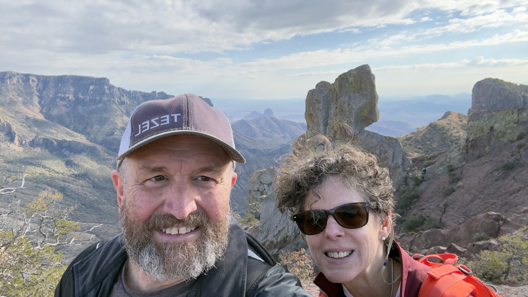
Near the end of the trail, the wash delivers you to the base of the final scramble — a steep climb over large boulders toward the gap where Balanced Rock sits. Small directional arrows painted on the rocks mark the route; look for them before committing to a line. The scramble requires using your hands in places and takes most hikers five to ten minutes. At the top, the valley opens up behind you and Balanced Rock fills the frame ahead.
Trail Map

Highlights Along the Way
The Sandy Wash
The wash is both the trail and the experience. Sandy desert washes are common in Big Bend, but the Grapevine Hills version has a particular quality — the walls rise steadily as you move deeper in, and the spires above take on new shapes from every angle. The soft footing slows your pace in a way that turns out to be useful; this is a trail worth walking slowly. There is no shade and no water anywhere on the route, so start early and carry more than you think you need.
Balanced Rock
At the top of the scramble, two massive boulders rest on a narrow stone base, balanced at an angle that looks engineered and is entirely geological. The Comanche people who traveled through this country had a name for formations like this: stones left behind by the Great Spirit. Standing in the gap beneath those boulders, looking back down the full length of the valley, that framing feels as fitting as any scientific explanation.
Laccolith Geology
The Grapevine Hills are a laccolith formation — magma that intruded between layers of existing rock roughly 30 million years ago without breaking through the surface, doming the overlying material upward. Over time, erosion stripped the outer layers away and exposed the hard igneous core. The result is the landscape you walk through on this trail: rounded, sculpted spires and boulders that look nothing like the sedimentary cliffs and canyon walls elsewhere in Big Bend.
What Makes This Trail Special
Most Big Bend trails put you on a ridge or canyon rim and ask you to look outward. The Grapevine Hills Trail works differently. You are inside the formation for almost the entire hike, surrounded by rock at eye level and above, the valley walls holding you in. The sandy wash builds a kind of anticipation that most desert trails don’t generate — you can see the spires the whole way, but you cannot see Balanced Rock until you’ve earned the scramble. That structure gives the trail a narrative shape that makes it memorable in a way a straightforward viewpoint hike is not.
Tips for Visiting
- Start early — there is no shade anywhere on this trail, and the Chihuahuan Desert sun is serious even in spring and fall.
- Carry at least two liters of water per person. There is no water on the trail or at the trailhead.
- High-clearance vehicles are strongly recommended for Grapevine Hills Road. Check road conditions at the visitor center before heading out.
- Look for the small directional arrows painted on the rocks at the scramble. They are easy to miss and mark the safest line up to Balanced Rock.
- Pets are not permitted on this trail.
- The trail is not heavily signed — pay attention on the return so you exit the right drainage from the wash.
Big Bend — 30 Million Years in the Making
Big Bend National Park encompasses 801,163 acres along a sweeping bend of the Rio Grande in far west Texas, protecting one of the most geologically complex and biologically diverse landscapes in the National Park System. The park spans three distinct zones: the river corridor, the Chihuahuan Desert lowlands, and the Chisos Mountains — a sky island rising above 7,800 feet that supports plant and animal communities found nowhere else in the United States.
The laccolith formations of the Grapevine Hills are one chapter in a geologic story that stretches back over 500 million years. Big Bend is one of the least-visited major national parks in the contiguous United States — its remoteness filters the crowds — which means the landscape you walk through here feels genuinely untrammeled in a way that parks closer to population centers rarely do.
Tuesdays on the Trail Video
This trail guide pairs with our Tuesdays on the Trail video episode, where we walk the Grapevine Hills Trail and explore the geology and character of this remarkable corner of Big Bend National Park.
Final Thoughts
The Grapevine Hills Trail asks two miles and a short scramble. It gives back a geology lesson, a Comanche origin story, and a view from beneath two boulders that have no business being balanced the way they are. Big Bend is one of the great parks — too far from everything to be convenient, which is exactly why it remains what it is. Go early. Bring water. Watch for the arrows.
Helpful Links & Resources
- Big Bend National Park – NPS Official Site
- Hiking at Big Bend – NPS Trail Information
- Big Bend Road & Trail Conditions
- Big Bend Geology – NPS
Tezels on the Road
More trails. More stories. More perspective.